| Bermuda |
1626 map of Bermuda from the James Ford Bell Collection at the University of Minnesota |
| Canada |
|
|
British Columbia Archives has high quality scans of nautical, topographic and land record maps |
|
Old Newfoundland maps, just a couple, includes other maritime provinces as well |
| Colombia |
1640 map of Colombia from the James Ford Bell Collection at the University of Minnesota |
| Croatia |
Image of Ortelius, 1575 map located at the Bodleian Library, Oxford |
| Cyprus |
Great site- from the Bank of Cyprus Cultural Foundation, a collection of over two dozen 16th-18th century maps, some with very high resolution scans
| Finland |
500 years of Finnish cartographic history, courtesy of the Ministry for Foreign Affairs and the Museum of Central Finland |
| France |
A collection of 100 18th and 19th century maps of Paris hosted by Prof Barry Bergdoll at Columbia University
A French site featuring old road maps; scans of map covers, mostly France but a handful of other Europe and some US, unfortunately not much in the way of maps themselves |
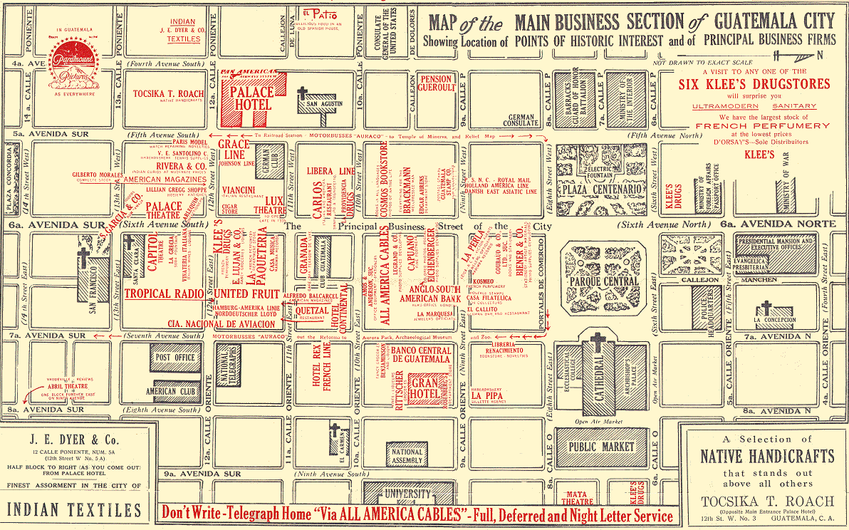
| Guatemala |
An interesting advertising map of Guatemala City ca 1950 from University of Cal Berkeley |
| Iceland |
A phenomenal site, result of a cooperative efforts of the National and University Library of Iceland and the National Library of Norway, includes a comprehensive collection of images across Iceland's history with multiple viewing resolutions |
| Israel |
Collection of Jerusalem maps from the Osher Map Library at the University of Southern Maine |
| Japan |
The Lanman Collection at Yale University is worldwide in scope, but has a decided emphasis on Asia, and Japan in particular |
| Liberia |
19th Century maps from the US Library of Congress |
| Mexico |
The Map Library of the University of Arizona has an exhibit of early Southwestern Cartography with images from the late 16th century through the 1850's, to include several covering all or most of present-day Mexico |
| The Netherlands |
George Welling's Historical Maps from Dutch Cartographers has extensive images from three 17th Century mapmakers covering the Netherlands and surrounding areas; good collection of high resolution jpeg's of Blaeu's Dutch city maps from the Toonneel der Steeden of 1652
The Royal Biblioteque's Map Collection page has a number of images with a wealth of historical information and links to other important collections
|
| Russia |
The Lada-Mocarski Collection at Yale University has over two dozen 16th, 17th and 18th century maps with a focus on Russia
The Early Russia collection of the University of Minnesota's James Bell Ford Library has 15th through 18th century maps |
| Spain |
Several dozen maps from the Enggass Collection of the Osher Map Library at the University of Southern Maine
Map of Ft Gordon, near Lerida, Spain drawn by George B. McClellan while a West Point cadet; courtesy Princeton University library |
| Switzerland |
The digital archives page of the Ryhiner Map Collection in Berne has a few images of 17th-18th century Swiss maps as well as a few nearby countries |
| United Kingdom |
Several assorted images, mostly UK but a copuple North America as well, from the Mapcase of the Bodleian Library at Oxford
The National Library of Wales Pictures and Maps Collection has a few images |
| United States |
Ray Sterner's Color Landform Atlas of the US has good, detailed scans of state maps from an 1895 Rand McNally atlas, covering all 50 states, mixed in with some good modern stuff as well
The Library of Congress' American Memory Collection includes several pages devoted to maps, to include ones with Civil War maps, National Park maps, Railroad maps, and Revolutionary War maps
A site at the Osher Map Library at the University of Southern Maine devoted to the Mitchell map of eastern North America (1750-1775), it's development and impact, with lots of good graphics
Early America dot com has a map page with a few decent scans of Revolutionary War era maps of the eastern US and specific Revolutionary War battle sites
The US Digital Map Library from US GenWeb is an effort within the genealogical research community to make a decentralized collection of scans of states and local areas across the US available.
|
|
The Map Library of the University of Arizona has an exhibit of early Southwestern Cartography with images from the late 16th century through the 1850's |
|
The Map Library of the University of Arizona has an exhibit of early Southwestern Cartography with images from the late 16th century through the 1850's
The 1851 San Francisco fire from Princeton University library |
|
The Colorado City Histoprical Society has maps of the city and region, some are nice scans of actual old maps, others are diagrams produced from historical sources |
|
MAGIC, the same site that brings you the Connecticut GIS Spatial Data Infrastructure node, has a truly PHENOMENAL historical maps site; a comprehensive collection from colonial times through early 20th century, fully zoomable through a Mr Sid viewer (along with a JPEG option as well)
UNH Dimond Library - Historical topo maps of New England - jpeg format, about 1.5 to 2 meg each, maps going back as far as 1893 |
|
The Hargrett Library Rare Map Collection at the University of Georgia has a great collection of detailed scans of maps of Georgia; lots of coverage of Florida as well, particularly from the colonial period |
|
The Hargrett Library Rare Map Collection at the University of Georgia has a great collection of detailed scans of maps of Georgia and surrounding states from the early colonial period forward
The Carl Vinson Institute of Government has a nice collection of Georgia maps, some with acceptably high resolution, from the colonial period through the 20th century; also hosts the Historical Atlas of Georgia Counties |
|
The University of Illinois Urbana-Champaign has a nice site with maps of Illinois and the old Northwest Territory, many with zoomable, high resolution images viewable on a Mr Sid viewer
The University of Illinois at Chicago has good quality scans from a Robinson 1886 Fire Insurance Map Atlas |
|
Old Kansas Area Maps is a UKans site with several maps, of particular note is a collection of 1883 county maps of the entire state |
|
The Moosehead Lake Region from the Osher Map Library at the University of Southern Maine
UNH Dimond Library - Historical topo maps of New England - jpeg format, about 1.5 to 2 meg each, maps going back as far as 1893 |
|
|
UNH Dimond Library - Historical topo maps of New England - jpeg format, about 1.5 to 2 meg each, maps going back as far as 1893 |
|
The Minnesota Historical Society Map Collection page |
|
UNH Dimond Library - Historical topo maps of New England - jpeg format, about 1.5 to 2 meg each, maps going back as far as 1893 |
|
The Map Library of the University of Arizona has an exhibit of early Southwestern Cartography with images from the late 16th century through the 1850's |
|
The Map Library of the State University of New York at Stony Brook has sites with 17th and 18th century maps of the region of New York state, and another site with a comprehensive collection of historical maps of Long Island, each with descriptive information and metadata
The Tompkins County GIS site includes a great collection of high-res scans of historical maps of New York and the Ithaca/Finger Lakes area. |
|
The Hargrett Library Rare Map Collection at the University of Georgia has a great collection of detailed scans; the focus is Georgia, but a lot of North Carolina is included as well |
|
UNH Dimond Library - Historical topo maps of New England - jpeg format, about 1.5 to 2 meg each, maps going back as far as 1893 |
|
The SCRoots Geneology site has a phenomenal map page, with what looks to be a complete 1825 atlas of the state, with locality maps at varying resolutions, to include some very high res options; lots of maps from surrounding areas as well, mostly 19th century
The Hargrett Library Rare Map Collection at the University of Georgia has a great collection of detailed scans; the focus is Georgia, but a lot of South Carolina is included as well |
|
The Virtual Map Library at the University of Texas at Arlington is a wonderful site. High res maps in Mr Sid format, use the viewer or download the files. Texas, as well as quite a few significant maps covering Mexico and other parts of the Southwest US. |
|
Sanborn Fire Insurance maps in high resolution, Mr Sid format at the J. Willard Marriott Library at the University of Utah; also other historical western US maps in the collection |
|
UNH Dimond Library - Historical topo maps of New England - jpeg format, about 1.5 to 2 meg each, maps going back as far as 1893 |
|
The Hargrett Library Rare Map Collection at the University of Georgia has a great collection of detailed scans of maps of Georgia and surrounding states; the Civil War section has, as you would expect, a great deal of coverage of Virginia included
University of Virginia library has 1907 and 1920 Sanborn maps of Charlottesville, very high resolution
|


